
SEQUATCHIE VALLEY
Sequatchie Valley is a geological region in the Appalachian Mountains between the Cumberland Plateau and Walden’s Ridge, just west of Chattanooga, Tennessee. At its southern end, it meets the Tennessee Gorge, and the whole valley is swirled around by the Sequatchie River and Tennessee River.
A few of the valley’s defining characteristics include kudzu-covered hills, expansive farmland and pastures, roadside produce stands, dazzling views of the water, and well-maintained state parks.
This blog is a culmination of multiple drives through the area with various people, and I would not recommend trying to see everything in the same day or weekend.

Sequatchie Valley covers Marion, Sequatchie, and Bledsoe counties. Many of the side quests I will mention in this blog will also lead you into Grundy County. and into the Mennonite community in Van Buren County between Dunlap and Spencer, TN.
Some of Sequatchie Valley’s major highlights include Fiery Gizzard State Park, Grundy Lakes, Savage Gulf State Park, Fall Creek Falls State Park, and the towns of South Pittsburg, Dunlap, and Pikeville.
Locals also like to claim the Prentice Cooper State Forest and Snooper’s Rock as part of Sequatchie Valley, and I am not here to stop them.
Driving through Sequatchie Valley, you will see countless historic sites from the Civil War, the coal mining and railroad industries of early settlement, and significant sites of Native American and Black history.

SEQUATCHIE VALLEY SCENIC BYWAY
Sequatchie Valley Scenic Byway is just one of thirteen famous byways in Tennessee, including Newfound Gap Road, Cherohala Skyway, East Tennessee Crossing, Norris Freeway, Ocoee Scenic Byway, Walton Road Scenic Byway, Great Smoky Mountains Byway, Great River Road, Tennessee River Trail Scenic Byway, Woodlands Trace, and Natchez Trace Parkway.
As you may have guessed, the Sequatchie Valley Scenic Byway is an officially designated route that takes you through the heart of the Sequatchie Valley, utilizing State Route 28/TN-28 and US-127 for over 70 miles.
Instead of starting the Byway in Kimball on SR-28, I rewound a bit. I started my trip in Chattanooga and took TN-156 from the Hales Bar Dam Powerhouse, through the Nickajack Lake region, and through New Hope.
When I reached South Pittsburg, I turned onto N. Cedar Avenue and then followed Main Street through Kimball and Jasper before connecting with SR-28.
This simply allowed me to see more of the region before starting the Byway, and I am so glad I did. I have driven the Byway a couple times before and there is so much to be missed if you do not venture out.
For those who are interested, there is also a 116-mile Sequatchie Valley Blueway.

HALES BAR DAM & NICKAJACK LAKE
From Chattanooga, I first visited the Historic Hales Bar Dam Powerhouse. The building and damn were built in 1913 but abandoned after decades of leakage issues that no one, not even TVA, could resolve.
The site is now owned by the Hales Bar Marina and home to Dam Whiskey Co.

It looks out over the water so you can imagine the kind of parties that go on there.

NICKAJACK LAKE is a nearly 50-mile segment of the Tennessee River, situated between the Chickamauga Dam northeast of Chattanooga over to the Nickajack Cave Wildlife Refuge near the TN/GA State Line.
The lake and cave were named Nickajack in honour of a former Cherokee town that once thrived there. While the cave has been there longer than humans have, the lake was created in 1967 when the Nickajack Dam was created to replace the defunct Hales Bar Dam.

Nickajack Bat Cave is famous for being home to hundreds of thousands of endangered grey bats that usually live there between April and August. The cave is primarily closed to the public since 2006 in efforts to prevent the spread of the White Nose syndrome fungus that has been killing bat populations, so consider this before trying to sneak around and cause irreversible harm.
Nickajack Cave is also well-known in certain circles as the place where Johnny Cash went when he was ready to give up. In his book Cash: The Autobiography, he had expressed his desire to end his life. After spending hours crawling around in the cave, his flashlight batteries died, so he lied down and waited to die too.
Thankfully, somehow, he had a change of heart. Cash says he found God in that cave, or rather “God found him” there. Some fans view a trip to the cave as an homage to the late Cash.
You can access the wildlife refuge via the Maple View Public Use Recreation Area in New Hope or book a guided tour with Chattanooga Guided Adventures, among other options.
If you have time, check out the Russell Cave National Monument just across the TN state line into Alabama.

NEW HOPE
One of my best friends has frequently mentioned how much she loves the drive through New Hope and Kimball, and it is easy to understand why. Towering kudzu-covered trees often line the curvy roads, framed by beautiful mountains in the background.

New Hope is a small community of around 1,000 people in a 10 square mile area.
The town incorporated in 1974, just narrowly avoiding annexation by the nearby city of South Pittsburg. Its trademarks include the Shelby Rhinehart Bridge, and of course the Nickajack Cave I mentioned before.

New Hope is also home to a unique site, the Shrine of our Lady Virgin of the Poor.

This shrine is a replica of the one in Banneaux, Belgium and it was built in 1982 by Benedictine monks.

It is open to anyone, of all faiths or none, for spiritual contemplation.

SOUTH PITTSBURG
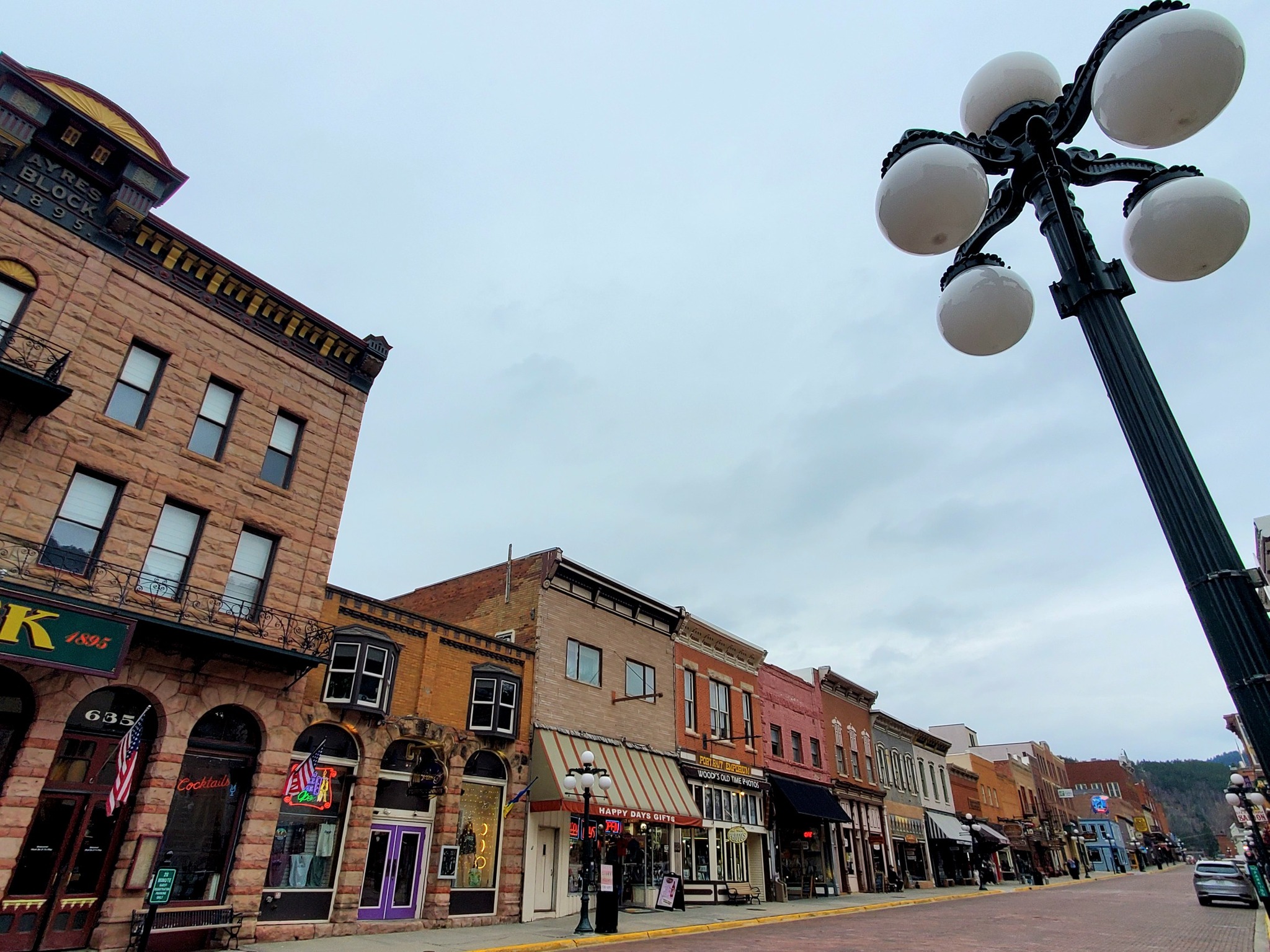
South Pittsburg is the most developed town in Sequatchie Valley, in my opinion, with the largest downtown and most options for social entertainment. It is part of the greater Chattanooga municipality, about 30 miles west of downtown Chattanooga.

Developers in the 1800s saw huge potential for miles and miles of agrarian land located along major rivers, near the Nashville & Chattanooga Railroad, and flush with coal and other resources that could be mined and transported.
They envisioned it as a new industrial capital, the “Pittsburg of the South,” and named it as such.

This area is extremely significant in Civil War history, Native American history including the Trail of Tears, and various railroad and mining companies.
Drop by the South Pittsburg Heritage Museum to learn more about that.

Each year, hundreds of thousands of people show up from around the country and even overseas to celebrate the National Cornbread Festival, and that is how I found myself there for the first time.

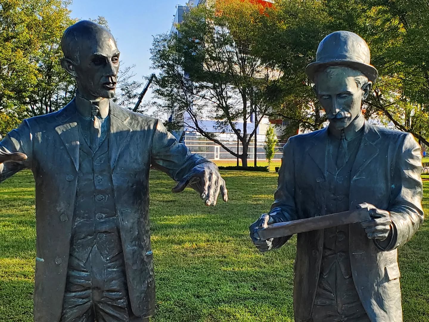
Lodge has opened a store and museum for the public to tour and pick up new favourite items. You can also hang out in their courtyard with all the “Skillet People” sculptures.

KIMBALL
Kimball is primarily a residential community with a handful of chain restaurants for entertainment. It is a quiet, peaceful preservation of the area’s mining history and full of views that make you stop the car or park somewhere and gawk at the sky.

JASPER
Next door, the community of Jasper has around 3,600 within nine square miles, and was formed back in the 1820s.


Jasper is most well-known for its gated residential complex high up on the mountain, and its Jasper Highlands Village of restaurants, shops, and a schmoozy fitness center that is open to the public.

We really enjoyed our visit to Top of the Rock Restaurant & Brewery. Like the name implies, it is at the top of a very steep mountainous drive.
The view during the daytime is worth the trip alone, but a meal in one of their reserved outdoor igloos is a different type of treat.

You can also visit the Jasper Regional History Museum and historic Jasper Depot, and take the Little Cedar Mountain Trail.


This is where you can take a side quest over to Morgans Steep, Franklin Forest, and Natural Bridge State Natural Area on the way to visit Sewanee Campus.

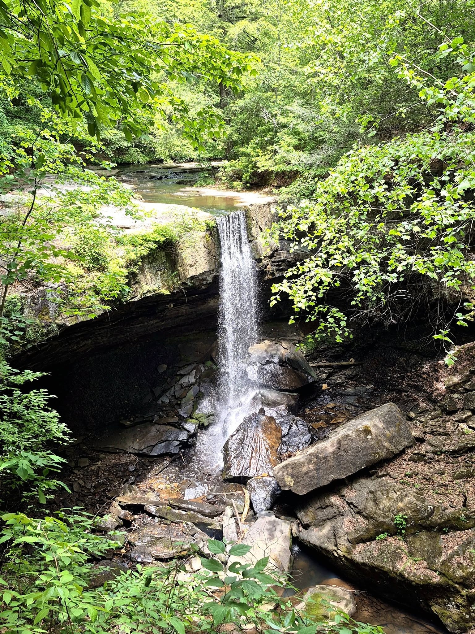
MORGANS STEEP is a popular spot for nearby students at Sewanee University of the South. A 2.3-mile trail from Morgans Steep to Sewanee Memorial Cross takes you by a lovely waterfall. It was a bit too chilly for the whole trail during our visit, so we only took part of the trail.

SEWANEE UNIVERSITY OF THE SOUTH is a liberal arts college that stretches out over 13,000 acres. It has been called the Hogwarts of the South (US) due to its heavy showcase of gothic architecture and ominously towering facades.


One of the country’s oldest publications, The Sewanee Review, is still in print quarterly.


Among nearly 40 other Majors, there is a strong focus on astronomy, space, and astrophysics around campus.


Check out any of the public telescopes you find and be sure to visit the Cordell-Lorenz Observatory.

WHITWELL
If you want to skip the visit to Sewanee, just continue on from Jasper into Whitwell.
Whitwell was incorporated in 1956 and is home to around 1,600 residents, the Whitwell Marion County Coal Miners Museum, Chimneys State Natural Area, Flying Camp Paragliding School, and the reason for my visit, the Children;s Holocaust Memorial.

The Children’s Holocaust Memorial is also known as the “Paper Clips Project” and is commemorated in a 1994 documentary of the same name.
A local teacher spearheaded this project to teach her students about the true horrors of genocide, particularly the Holocaust, and the magnitude of what six million might look like.
The project was inspired by Norwegian resistance to Nazism by wearing paperclips on their lapels, and ultimately resulted in the students receiving historically significant and brand new paper clips from all over the world.
Accompanying the paperclips were heartfelt letters from survivors and relatives of those who did not survive, and a share of hate mail against the memorial.

I remember seeing a news article about this when I was younger, about the same age as the students undertaking this project, and feeling very inspired. You can view the Paper Clips Project on various platforms.

POWELLS CROSSROADS
I drove through Powells Crossroads but did not spend much time there. It is another lovely residential community like Kimball with a few local attractions like Ketner’s Mill, restaurants like the acclaimed Sue Bob’s Diner, and Raccoon Mountain Caverns & Campground.

SEQUATCHIE CAVE
I decided to keep wandering around the area a bit more instead of adhering to the Byway, and I encourage you to do consider the same.
In the town of Sequatchie, check out the 122-acre Sequatchie Cave State Natural Area. There is a generous amount of space to park before entering the shallow wading pool that leads toward the cave opening, and you can feel the cold air coming out of the cave from a distance.

I wandered around a bit and stuck my feet in the water before moving on, since couples and families were starting to move in for afternoon picnics.

TRACY CITY
From here, the trip progressed through the Foster Falls Recreation Area, White City, and to Tracy City
After seeing and hearing various friends gush about how amazing Tracy City is, I made sure to stop in. I learned that there are around 1,500 residents there and the town was finally incorporated in 1915 despite having its origins around 1840.


I also learned that some of Tracy City’s old coke ovens are now on the National Register, and that a Swiss emigrant who was born in Tracy City later returned to his ancestral grounds before moving onto Germany, becoming a National Front activist, and eventually a convicted criminal.


Tracy City is one gateway to the Fiery Gizzard State Park, named after the experimental blast furnace I mentioned before.

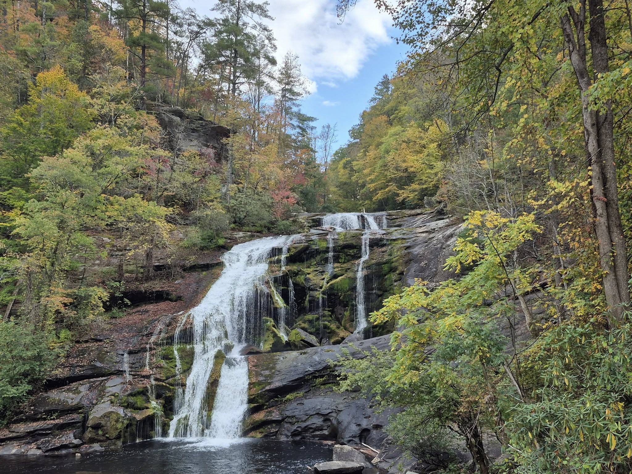
Trekking to the Upper and Lower Greeter Falls, Denny Cove Falls, and Boardtree Falls are a few crowd favourites. I started walking from the Denny Cove Access Point and continued on for part of the trail, but decided to return when I have a hiking buddy and it is not so hot outside.


BEERSHEBA SPRINGS was a cute community I drove through to get to Savage Gulf State Park, complete with a tiny history museum and fire department.


The North / Stone Door entrance and the East entrance are most popular, with ranger stations, gift shops, bathrooms, and easy access to trails and campgrounds.


Savage Falls, Greeter Falls, the Blue Hole, and Suter Falls are all gorgeous.

From Savage Gulf, I drove through Gruetli-Laager, another quaint and mostly residential community, and on to Dunlap. Gruetli-Laager was originally two separate communities, founded by Swiss / Swiss-Germans in 1869, that combined and incorporated in 1980.

A century before, in the 1880s, this was the largest Swiss community in Tennessee. Founders had been advertising the settlement back home in Switzerland to attract new families. Once they arrived, however, many were disappointed in the land quality and remoteness, so they moved on.

DUNLAP
Of all the towns and cities along the Sequatchie Valley Scenic Byway, I found Dunlap to be the second-most lively after South Pittsburg. It has a small downtown with several shops, restaurants, bars, and even a recording studio.
Dunlap’s population is creeping up on 5,000 which is half of all of Sequatchie County’s total population.

Dunlap is known for an abundance of historic sites related to the Civil War and, oddly enough, for being the “Hang Gliding Capital of the East.”
The city is proud to host the Tennessee Tree Toppers paragliding group and to have been the home of the historic East Coast Hang Gliding Championship events.

Some of Dunlap’s most popular attractions include the Rolling Oak Distillery, The Yard, and the Sequatchie Valley Brewing Company where I stopped in for a delish Cubano flatbread.

The Sequatchie Valley region’s history is synonymous with coal mining history, something that is celebrated and memorialized in the famous Historic Dunlap Coke Ovens Park and Museum.

The park itself is a vast, beautiful greenspace and is peppered with old mining relics and informative signs.

Stroll around and have a picnic in the park at your own pace, or reserve a guided tour.

Two large old coke ovens greet you on either side of the drive into the museum parking lot line stone lions from a parallel universe. Museum admission is free but donations are encouraged to upkeep the building and grounds that preserve this history.

FALL CREEK MENNONITE COMMUNITY
Just outside of Dunlap toward Spencer, TN, the Fall Creek Mennonite Community has several shops and businesses that are open to the public, primarily along Brockdell Road and smaller connecting roads.


The drive through here is an experience of its own, with rustic farmhouses, farms as far as you can see, and adorable horses and cattle that watch curiously as outsiders go by.


Be prepared to share the road with horse drawn carriages and farm equipment around every curve.


Several offerings include produce stands and shops with baked goods, jams, jellies, syrups, bread, various pickles, and other specialties.


You can also peruse their hardware, textile, furniture, home goods, gifts, garden supplies, bikes, books, leather products, and more as you continue through the community.

Here is a map and business directory I found on the CityofSpencer.gov website:


Be prepared to pay in cash. I did not visit every shop in the directory, but several had signs up that they only accept cash. It would be a total disappointment to make the trip only to find that you can not take anything back with you.

PIKEVILLE
The most northern city of the Sequatchie Valley Scenic Byway is Pikeville.
Some of its historic attractions include the old Historic Bellview School, the Old Town Spring, the historic County Courthouse and Bledsoe County Jail, a former Rosenwald School, and the Dr. James A. Ross Medical House Museum.


Pikeville’s historic Main Street district is on the National Register of Historic Places. It could be defined by Victorian homes and Bungalows that line both sides of the landscaped street, some of them tucked securely behind stone walls.


More modern day attractions include the Bankwalker Brewing Co., an ice cream and coffee shop, and a cool little nook built in between historic buildings that houses a stage and meeting space.


I especially enjoyed the murals inside that pay homage to this region’s Indigenous history and cultural influence.


FALL CREEK FALLS STATE PARK is one of the largest and most visited state parks in all of Tennessee, spanning almost 30,000 acres.

Fall Creek Falls proper are nearly 260 feet high, making this one of the tallest falls in the eastern half of the US.
There are a few trails to choose from, but most people either take the 0.1 connection to the overlook or the 0.5 trail down to the base of the falls. The latter can be strenuous and slick if it has been raining or if it is icy.

We visited the falls, drove the scenic loop, and set up post at the lodge for a few hours.

The Lodge at the Fall Creek Falls State Park looks out over the shimmering, 345-acre, aptly named Fall Creek Falls Lake.

For a tourist lodge, prices were pretty reasonable. We tried their spinach florentine chicken, grilled shrimp skewers, land and sea basket with fried cod and shrimp, corn fritters, and the State Park’s official blonde beer.


Be sure to get out and walk around the lake a bit after your meal.

Of course the most thrilling, unexpected aspect of this trip was spotting about half a dozen armadillos playing together.

Beyond that, the Sequatchie Valley Byway leads into Crossville, TN, and you can read my blog about Crossville here.
You might notice signs for another route crossing through this region called the Pie in the Sky: Moon Pies to Mountain Highs Trail. This 363-mile self-guided driving route was named after the locally produced snack cake, the Moon Pie, and was unveiled and marketed a lot around 2011-2013 but seems like it might have dwindled a bit in favour of the Sequatchie Valley Byway.
You will see signs for Pie in the Sky all around this region, as both routes share many attractions and span the same territory.
Here is a link to a story about Pie in the Sky.

In the area for a while? Follow me to Crossville, to some of my favourite Chattanooga neighbourhoods like Riverfront, Southside, South Broad, and Historic 9th Street, or a few North Georgia gems like Dalton, McCaysville, and Blue Ridge.
*************
© Fernwehtun, 2015- Current. Unauthorized use and/or duplication of this material without express and written permission from this site’s author and/or owner is strictly prohibited. Excerpts and links may be used, provided that full and clear credit is given to Fernwehtun and Fernwehtun.com with appropriate and specific direction to the original content.


Leave a Reply