
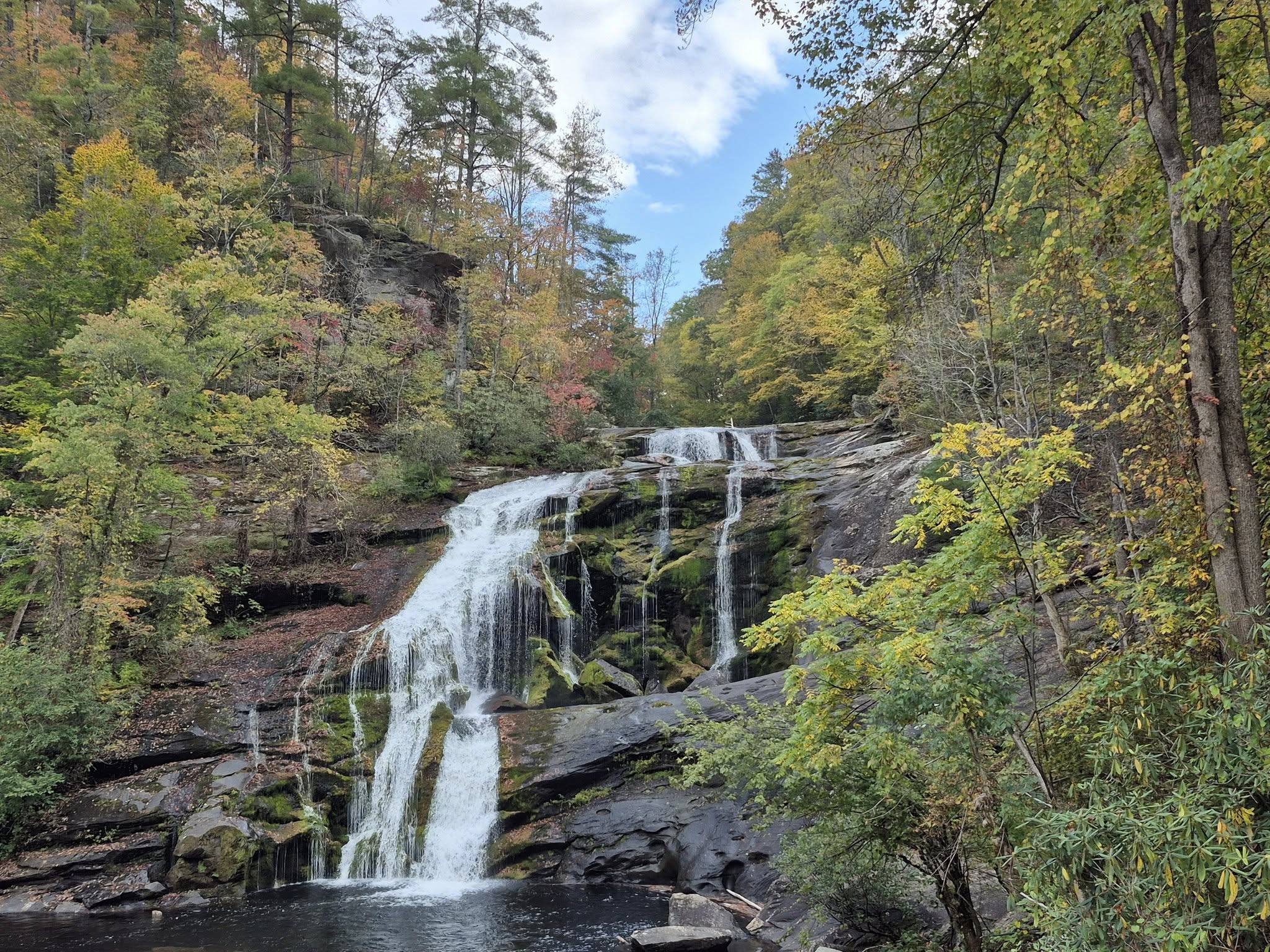
CHEROKEE NATIONAL FOREST is located in Tennessee and North Carolina along the shared state boundaries, and it crosses through the Great Smoky Mountains National Park. Its northeast point is Backbone Rock at the TN/VA border, and its southwestern point is its headquarters in Cleveland, TN.
The forest spans more than 655k acres and is known for its gorgeous mountain views, famous hiking trails, Olympic-grade whitewater rafting rivers, enhanced scenic drives, and gushing waterfalls.
Highlights include the Great Smoky Mountains National Park, Cherohala Skyway, Ocoee and Hiwassee Rivers, Roan Mountain, the Appalachian Trail, and numerous mountain towns.
This land first belonged to the Cherokee people. Cherokee is an Anglicism of “Tsalagi” which means “the principal people” and that is what the Cherokee call themselves.
Some sources says the word Cherokee comes from the Creek word “Chelokee” meaning “people of a different speech” but this forest and many other regional destinations are consistently named “Cherokee” to honour the Cherokee people.

Cherokee National Forest is divided into three geographic sections: the Northern and Southern sections that each contain two Ranger Districts, and the Great Smoky Mountains National Park region located in the middle of them.
Collectively, the three districts have fifteen recreational regions. I will write this blog as though you are traveling from North to South.
This screenshot shows the general area that this route will cover. You can also click here to view some official park maps, and scroll down to the end of this blog to read my route planning suggestions.

1. NORTHERN SECTION: WATAUGA & UNAKA RANGER DISTRICTS
From the TN/VA state line down to the Great Smoky Mountains National Park, the Northern Section includes eight “recreation regions” which are not the same as official Ranger Districts. Think of the hierarchy as Forest > Section > Districts > Recreation Regions.
The entire Northern section is traversed by the notorious 2,200-mile Appalachian National Scenic Trail. Recreation regions of the Northern section’s Watauga & Unaka Ranger Districts include the Holston Mountain, Iron Mountain, Watauga Lake, Roan Mountain, Unaka Mountain, Bald Mountain, French Broad, and Pigeon River regions.
Here are some of my favourite spots in the Northern Section.

HOLSTON MOUNTAIN REGION
Starting east of Bristol near the TN/VA state line, the Holston Mountain Region is also in close proximity to Elizabethton, Bluff City, and Shady Valley, TN. My two favourite spots out there are Blue Hole Falls in Elizabethton and the South Holston Lake closer to Bristol.
BLUE HOLE FALLS are actually a series of waterfalls that connect and flow down the mountain as you go. It is a short 0.3-mile walk from the dusty streetside parking nook in a rural residential community to the first upper falls.

As you continue down the path, you will a few more waterfalls and coves to your right. There are shallow pools for swimming but consider each one with caution before entering.

The rocks can be slick but having this all to ourselves for a little while was like a dream.

SOUTH HOLSTON LAKE is a 7,500+ acre lake known for boating and white bass fishing. If that is your thing, Washington County is particularly excited to inform you that you can purchase a single fishing license that allows you to fish in both states that the lake covers.
I prefer to just chill and read a book or walk around.

SHADY VALLEY is an unincorporated community in Johnson County between Backbone Rock and Elizabethton. It is primarily known for its Shady Valley Country Store and being a hub for The Snake, a wildly curvy 37-mile motorcycle route, plus its annual Shady Valley Festival of Quilts, and a few cool bog ecosystems like the Orchard and Quarry bogs.

More than anything, it is a celebrated pit stop mecca for bikers. The Shady Valley Country Store has really awesome grab-and-go breakfast biscuits and wraps, or you can dine in.
Count on making new biker friends, maybe check out a few sports car clubs that share the driving route, and fill your belly with southern hospitality.

The ceiling and walls are covered with random bits and bobs that have been left behind from various motorcycle crashes, reminding participants to protect their necks.

ELIZABETHTON was founded in 1799 and holds the title of many firsts; the site of the first independent settlement of white folk west of the thirteen original colonies, and west of the Eastern Continental Divide, its Sycamore Shoals Carter Mansion is the oldest building still standing in the entire state, and it has one of the first constitutional governments written somewhere west of the Appalachian Mountains.
You can read more about Elizabethton at the end of this blog.

IRON MOUNTAIN REGION
This region is home to Backbone Rock Recreation Area, Backbone Rock, and Backbone Falls.
Iron Mountain is known for its ruggedness and is ideal for anyone looking for longer, days-long hikes like the 19-mile Iron Mountain Trail #54 or the over 50-mile back country hike around the Iron Mountain Trail to the Cross Mountain-Damascus section of the Appalachian Trail.
Backbone Rock Recreation Area is the most popular camping site but there are plenty of primitive campgrounds and open space to set up tents.
To start, Big Laurel Branch Wilderness, Beaverdam Creek, London Bridge Branch, and Rogers Ridge all offer a combined 25,000+ acres of back country space.
Watauga Lake and the Osborne Farm are also popular attractions.

BACKBONE ROCK is called the “shortest tunnel in the world” and is only 22 feet long. It was created for the Beaver Dam Railroad by the Civilian Conservation Corps (CCC) in 1901 to connect Shady Valley, TN to Damascus, VA.
Turns out it was not carved out high enough for a train’s smokestack to pass through so some revisions were made, which explains its odd bell jar shape. This railway path was abandoned in 1918, and then widened so that TN SR-133 could be created in its place.

There were so many beautiful rhododendrons lining the trail. We were enthusiastic to start the hike toward Backbone Falls, but unfortunately it became too icy and dangerous to continue, so we will try again in Spring.

WATAUGA LAKE REGION
The Watauga Lake region is near Elizabethton and Roan Mountain, TN. Watauga Lake itself is a 6,430-acre lake that was created in 1942 when the Tennessee Valley Authority impounded three other local sources: Watauga River, Elk River, and Roan Creek.

ROAN HIGHLANDS REGION
The Roan Highlands Region is near Roan Mountain, TN and Roan Mountain State Park, and Bakersville, NC. Some of its most popular features are Roan Mountain State Park, Moffett Laurel’s Botanical Area, Ripshin Ridge, Roan Massif, and Hampton Creek State Natural Area.
ROAN MOUNTAIN is a small CDP community in East Tennessee near the North Carolina border, best known for Roan Mountain State Park and the Roan Mountain Rhododendron Festival. Roan Mountain itself is one of the highest summits in the Appalachian Mountain range.

While you are there, you can visit the famous Carvers Gap with access to the Appalachian Trail.

UNAKA MOUNTAIN REGION
The Unaka Mountain region is closest to Erwin and Unicoi, TN, home of the Erwin-Unicoi County Apple Fest. A man I dated in Jonesborough and his friends once took me “Jeeping” through Bumpus Cove, which the locals like to call “BumpASS Cove” because riding up to the top will bump every cell in your body out of place.
We got stuck VERTICALLY halfway up so two of them had to jump out and push the Jeep back over onto all four wheels. I was covered in foul-smelling mud, bruises, and even got cut once, but we were laughing and hollering the whole time. Those country boys did not think a city girl could hang, but I hung.
(…on for my life)

Other popular spots in this region include the Pinnacle Mountain Fire Tower located on Buffalo Mountain, hiking The Laurels area, Limestone Cove, the historic Rock Creek Recreation Area, Rock Creek Falls, and the Nolichucky Scenic River.

While you are in the Tri-Cities area, consider stopping by Southern Craft BBQ. This is a regional chain with just a handful of locations, and they offer barbecued chicken and pork for those who do not eat red meat.
We loved sampling all of their homemade sauces, especially the Carolina style and vinegar based ones.

We all tried several dishes including their specialty fries and a few sandwiches.

BALD MOUNTAINS REGION
The Bald Mountains region is nearest to Greeneville, and its most popular attractions are the 60-feet tall Margarette Falls, Bald Mountain Ridge Scenic Area, Sampson Mountain Wilderness, Big Butt Bald (I see you smirking), and Horse Creek or Dry Creek for fishing.

GREENEVILLE is Tennessee’s second oldest town after Jonesborough, and it has the distinction of being the only Greeneville in the USA spelled with an “e.” It is part of the great Tri-Cities area of East Tennessee and includes the community of Limestone where famous frontiersman David “Davy” Crockett was born, even though he hated being called Davy.
Greeneville was voted capital of the unofficial State of Franklin from 1785 until 1788 and the Greene County Courthouse is the only courthouse in the USA that has both Union and Confederate monuments onsite, exemplifying its history of intense social and political dualities.
Read more about Greeneville here.

VIKING MOUNTAIN OVERLOOK is a fun stop with a stunning view.

YODER’S COUNTRY MARKET is an Amish store and deli located in Bull’s Gap, a 15-minute drive from downtown Greeneville.

Stop in to stock on dry goods, fresh bread and sweet treats, cured hams, jams, jellies, pickles of all types, fresh produce, and other Amish delicacies.
You can also walk up the deli counter, fill out a little sandwich ticket, hand it to one of the workers, and they will have it ready to go within minutes.

FRENCH BROAD RIVER REGION
The French Broad River Region is situated between Greeneville and Newport, TN and Hot Springs, NC.
If pressed, I would say that this is my favourite region of the Cherokee National Forest because it is close to and often within my beloved western North Carolina and my second home, Asheville.

Some of the most popular spots here are Max Patch, Paint Creek, Brush Creek, Allen Branch, and the Appalachian National Scenic Trail #1 access point.

The main attraction here is the French Broad River, of course. See if you can find this giant boulder at my favourite roadside spot.

HOT SPRINGS, NC can be just as ornery as it is charming, depending on the season. It is a hub for Appalachian Trail hikers so you can often find them stretching or stretched out all over the streets.
The town first became famous for its natural mineral springs and the tourists it attracted. Business dwindled at the start of WWI and it was eventually taken over by the US government and used as an internment camp that lasted for about a year or so between 1917-1918, mostly for non-combat German agents and their families. Many of them became close friends with American soldiers and civilians living in Hot Springs. Some even stayed behind once the war ended.
Read more about Hot Springs here.

NEWPORT, TN was first settled in the 1780s and named so because it was literally a new port along the French Broad River to support new settlements, but today it is full of fairly well-preserved 1920’s-era buildings.

PIGEON RIVER REGION
The Pigeon River Region is nearest to Del Rio, Newport, and Cosby, TN as well as Waynesville, NC. At this point, you will be at the southern end of the Northern District, getting close to the Great Smoky Mountains National Park.
Popular spots in this area include the Martha Sundquist State Forest, part of the famous Foothills Parkway, the Round Mountain Recreation Area, and yet another access point to “The AT.”
COSBY is a small community near Newport, and my favourite place there is Carver’s Orchard and Apple House. You can pick your own apples, or browse dozens of varieties inside the farmhouse, then have a meal at the restaurant. I have been a few times now and love it.
Read more about Cosby, Newport, Cocke County, and other places that overlap the Great Smoky Mountains Byway in this blog.

WAYNESVILLE & LAKE JUNALUSKA, NC are in the heart of Haywood County and it is said that the last shot of the Civil War east of the Mississippi River was fired in Waynesville during May of 1865.

LAKE JUNALUSKA is a peaceful North Carolina retreat that has thrived quietly for over a hundred years. Slightly under 3,000 people live in this area of less than six square miles.
Lake Junaluska is an ubiquitous name, referring to the 200-acre man-made lake itself as much as it does the community surrounding it, and its world-renowned religious conference center.

MARTHA SUNDQUIST STATE FOREST is a 2,000-acre forest that is almost completely surrounded by the Cherokee National Forest.

The lovely forest does not have much development inside it and is primarily known for horseback riding, fishing, and its open bear hunting season.

HARTFORD is a great access point to the Martha Sundquist State Forest.

I have had many meals (hello peach grilled cheese!) and seen several great live concerts at Beantrees Cafe in their back patio garden that looks out over the water. 
This tiny little community is a significant hub for whitewater rafting, with several different guided options available on one intersection.

2. GREAT SMOKY MOUNTAINS NATIONAL PARK SECTION
Since I have already written extensively about the Great Smoky Mountains National Park Region which overlaps the southern section of the Blue Ridge Parkway and many other scenic and tourist routes, check out this blog for more info about the Great Smokies!

3. SOUTHERN SECTION- OCOEE & TELLICO RANGER DISTRICTS
From the Great Smoky Mountains National Park (GSMNP), travel southwest through Tennessee toward the TN/GA state line.
Cherokee National Forest’s Southern Section includes the two ranger districts of Ocoee & Tellico, which contain the seven recreation regions of Citico Creek, Tellico River, Coker Creek, Starr Mountain, Hiwassee River, Ocoee River, and Big Frog Mountain. Cherokee National Forest’s Southern section is traversed by the Benton MacKaye Trail.
Remember to think of the hierarchy as Forest > Section > Districts > Recreation Regions.
Here are some of my favourite spots in the Ocoee & Tellico districts.
CITICO CREEK REGION
The Citico Creek Region is close to Tellico Plains, TN, the Cherohala Skyway, Robbinsville, NC, the 22,000-acres Citico Creek Wilderness and campgrounds, and Joyce Kilmer-Slickrock Wilderness.
Joyce Kilmer Memorial Forest can be accessed from NC 143 onto a a two-mile side quest loop through this lovely forest of poplar and hemlock trees.

ROBBINSVILLE is a tiny town with just 0.4 square miles and around 600 residents. Scenes from the films Nell and The Fugitive were filmed here, and the Avett Brothers released an ode to the town called Four Thieves Gone: The Robbinsville Sessions.
The nearby Lake Santeetlah is just six miles from Robbinsville and about fifteen minutes from the Great Smoky Mountains National Park. Lake Santeetlah is the name for the the town itself and its gorgeous, award-winning lake that has been voted the most beautiful lake in America.

TELLICO RIVER REGION
The Tellico River Region is near Tellico Plains, Indian Boundary Lake & Campground, Cherohala Skyway, & Bald River Falls, and it is one of my favourite regions of the whole forest.
TELLICO PLAINS is a tiny gateway town to the Cherohala Skyway that has less than 1,000 residents. This land used to be an Overhill Cherokee village called Telliquah and is packed with Cherokee and Muscogee history, from the Tellico River to the Unicoi and Appalachian Mountains.
Check out the Bears Den Café, Tellicafé, Tellico Grains Bakery, Trout Mountain Coffeehouse & Inn, Tellico Outfitters, Stone Cottage Shops & Gardens, and The Bookshelf while you are in Tellico Plains, and read my blog about Tellico Plains here.
CHEROHALA SKYWAY is a 43-mile National Scenic Byway that connects Tellico Plains, TN to Robbinsville, NC. “Chero-” comes from the Cherokee National Forest, and “-hala” comes from the Nantahala National Forest, both connected by the Skyway.

BALD RIVER FALLS is near the beginning of the Skyway in Tellico Plains, and it is a hub for white water rafting and fishing.

You will need to drive several miles down the newly paved and reopened River Road right off Cherohala Skyway to visit to the 100 feet high falls, which can be seen from the road.

Indian Boundary Campground is right off Hwy 165, that also leads to Boundary Lake.

When you reach the beach, you can spread out on the grassy hill overlooking the sand or you can post up right by the water.

COKER CREEK REGION
The Coker Creek Region is closest to Coker Creek, Turtletown, Ducktown, and Copperhill, TN following TN-68 toward McCaysville and Blue Ridge, GA.
Some of the most popular attractions here include the Hiwassee State Scenic River, the Coker Creek Falls Trail #183, and the 2.5-mile Unicoi Turnpike Trail through one of the oldest known travel routes in North America that later became part of the Trail of Tears.
COKER CREEK is also known for its camping retreats and the Coker Creek Scenic Area waterfalls.

DUCKTOWN is a tiny, mostly residential, one-intersection town in a historic geological region called the Copper Basin.
You can read more about Ducktown & the Copper Basin here or by visiting the Ducktown Basin Museum.

COPPERHILL & MCCAYSVILLE are twin towns on either side of the TN/GA state line, though McCaysville is more lively and full of shops, restaurants, and breweries.
My sister lived just a few minutes away in Blue Ridge, GA for four years, so we have tons of memories in this area. You can read about Blue Ridge here and here.

BIG FROG MOUNTAIN REGION
The Big Frog Mountain Region is west of Copperhill & McCaysville, also hovering the TN/GA state line. The Conasauga River, Conasauga River Trail #61, Big Frog Trail #64, the Cohutta Wilderness, and Georgia’s Chattahoochee-Oconee National Forest are all extremely popular attractions.
While I am very well-traveled in Copperhill & McCaysville, I have regretfully not spent much time in the Big Frog Mountain region yet. I am working on a separate blog about the Chattahoochee-Oconee National Forest that will include more information.

STARR MOUNTAIN REGION
The Starr Mountain Region is closest to Etowah, TN, and its most popular attractions include the Gee Creek Wilderness, Gee Creek Trail #191, Gee Creek State Park, a little called Reliance, several significant Tennessee Overhill Cherokee sites, and Starr Mountain itself.
ETOWAH is a tiny town of less than three square miles that co-hosts numerous Cherokee and Native American heritage festivals with its neighbouring town of Athens, and is home to Starr Mountain Distillery. You can read more about Etowah here.

The Tennessee Overhill Heritage Association is in the historic Etowah depot, functions as a ticket office for the Tennessee Valley Railroad, and houses the Etowah Depot Museum with various exhibits and events.

HIWASSEE RIVER REGION
The Hiwassee River Region is between the towns of Etowah and Benton. Hiwassee River State Park, Hiwassee River Gorge, Big Bend River, the L & N Railroad bridge, the John Muir National Recreation Trail #152, Benton MacKaye Trail, Appalachia Powerhouse, and Towee Ceek are its main attractions.

RELIANCE is quite rural but still a recognized historic district.

OCOEE RIVER REGION
The Ocoee River Region is another one of my favourite parts of the Cherokee National Forest and it is closest to the forest’s headquarters in Cleveland, TN.
Its most popular attractions are the Ocoee River, Goforth Creek, Parksville Lake, Chilhowee Mountain and Recreation Area, and McKamy Lake Beach.

OCOEE COUNTRY has the Ocoee and Hiwassee Rivers, and is Olympic-famous for whitewater rafting and has options like Outland Expeditions, Ocoee River Rafting, High Country Adventures, Cherokee Rafting- Ocoee River Whitewater, Ocoee Watersports, NOC Ocoee Outpost, Ocoee Outdoors, Raft One Ocoee Rafting Outfitter, Ocoee Adventure Center, and Wildwater Ocoee River Basin Canopy Tours.

CHILHOWEE MOUNTAIN & Recreation Area has several gorgeous overlooks to Sugarloaf Mountain and can be accessed by the seven-mile paved Forest Service Road 77.

MCKAMEY BEACH & LAKE is a seven-acre lake built by the CCC between the 1930s and 1940s and guests enjoy swimming, fishing, canoeing, and having picnics. You can also hike the Chilhowee Lake Trail that starts right along the water.

PARKSVILLE BEACH and Mac Point Beach are situated along Parksville Lake which is sometimes called Lake Ocoee, and is the oldest man-made lake in Cherokee National Forest.

Check out my blog about the 26-miles long Ocoee Scenic Byway blog for more information on other nearby natural attractions, historical sites, and places to eat and shop.

LOGISTICS & ROUTE PLANNING
I wrote this blog as if you are traveling from Backbone Rock down to Cleveland. You can follow it however you like, but here are a few things to consider when planning your route:
1. If you start at Backbone Rock/Falls then visit Shady Valley and South Holston Lake, consider visiting Bristol. The twin-city of Bristol, TN/Bristol, VA is near South Holston Lake and is a great place to visit, but it is pretty far off the main route through Cherokee National Forest.
2. Between Blue Hole in Elizabethton and Erwin, I have two suggestions:
-The first is to drive from Blue Hole to Roan Mountain State Park & Carvers Gap, then take a side quest from Carvers Gap to Cranberry, Beech Mountain, Banner Elk, Boone, Blowing Rock, Grandfather Mountain, Linville, Spruce Pine, Bakersville, and then go back to Roan Mountain in one giant clockwise loop. This will lead you through some of the most beautiful natural attractions and could easily be a multi-day or week trip on its own.
-The second suggestion is to drive from Blue Hole to Johnson City, Jonesborough, then Erwin, which means skipping Roan Mountain and the side quest.
-If you have the time, do both!
3. From Erwin Hot Springs, I would suggest a stop at Margarette Falls and to explore Greeneville before you go to Hot Springs. The drive between Hot Springs and one of my favourite picnic spots in the nearby town of Marshall is right along the beautiful French Broad and takes less than an hour round-trip.
4. From Hot Springs to Newport and Cosby, you will be driving through the Martha Sundquist State Forest, Cataloochee Valley, Lake Junaluska, and then reaching Waynesville.
5. From Waynesville to Robbinsville, I would suggest driving through Maggie Valley, Cherokee, and the Great Smoky Mountains National Park. Alternatively, you can drive further south through Sylva and Dillsboro. Both routes will lead you from Waynesville to Robbinsville.
6. From Robbinsville to Tellico Plains, take your time driving through Tellico Plains, stop at Indian Boundary Lake, consider camping at Citico Creek, and do not miss out on seeing the roadside Bald River Falls.
7. From Tellico Plains to Etowah, I would suggest driving the loop through Coker Creek, Turtle Creek, Ducktown, Ocoee, Cleveland, Benton, and then Etowah.
There are so many ways to travel through the Cherokee National Forest. Choose your own adventure!

In the area for a while? Visit other regional forests and national parks like The Great Smoky Mountains National Park, Daniel Boone National Forest, Pisgah National Forest, and Nantahala National Forest (in progress).
*************
© Fernwehtun, 2015- Current. Unauthorized use and/or duplication of this material without express and written permission from this site’s author and/or owner is strictly prohibited. Excerpts and links may be used, provided that full and clear credit is given to Fernwehtun and Fernwehtun.com with appropriate and specific direction to the original content.


Leave a Reply